
Trace a Del City Street
A Del City street search works best as an address-to-record sequence. First standardize the written address, then use the county account and legal description to keep later results on the correct parcel. The Assessor is a fast starting point, while the County Clerk holds the recorded instruments that explain ownership transfers. Map layers help locate the parcel and its addition, but they are not a survey. Historic directory and newspaper work comes last, after the address, subdivision, and nearby intersection are known.
- Use USPS ZIP Lookup to retain the current mailing form, while keeping the Del City municipal label if the postal city differs.
- Run the block number, directional prefix, and street name through the Oklahoma County Assessor Public Access search. Save the county account, physical and mailing addresses, legal description, subdivision, and lot or block.
- Open the parcel in the Oklahoma County GIS Hub to check parcel shape, addition, roads, boundaries, and possible adjacent parcels.
- Search the legal description, grantor, grantee, or instrument reference in the Oklahoma County Clerk public-access index, then inspect the recorded image or request an official copy when needed.
- For an older household, compare Metro or OHS directory street-index pages with the alphabetical entry and a dated newspaper result. The Oklahoma Voter Portal is only an individual lookup after a name and date of birth are known, not a street roster.
This order separates parcel ownership from occupancy and gives a street result a date. It also leaves a clear trail when an address is absent from one source.
Search Del City Streets in the Assessor
The Oklahoma County Assessor makes several paths available for a Del City street directory search. The physical-address field expects the block number before the street and needs a directional prefix or wildcard. Owner searches use last name first, ignore case and punctuation, and accept a percent sign as a wildcard. When the address returns nothing, that does not end the search. The office assesses by legal description, so subdivision, block, lot, map number, deed book and page, or account number can be the better route.
| Assessor field | How it works | Useful Del City result |
|---|---|---|
| Physical address | Block first; use direction or wildcard | Address-to-account lead |
| Name | Smith John or Smith J%; no punctuation | Owner-of-record lead |
| Real account | R plus nine digits | Exact parcel account |
| Subdivision, block, lot | Partial text and wildcard accepted; lot is three digits | Addition and plat research |
| Deed book and page | Separate book and page fields | Cross-check with the Clerk index |
| Map number | Published range is 1001 through 4944 | Map-based parcel route |
The Assessor office is at 320 Robert S. Kerr Avenue, Room 313, in Oklahoma City, and lists 405-713-1200 for the office and 405-713-1229 for GIS support. The online search is free and continuously available. Its legal description is a practical locator, not the final word on the recorded instrument. Keep the search date because owner, value, and sales fields can change.
See the official Assessor search page before entering a Del City street address.
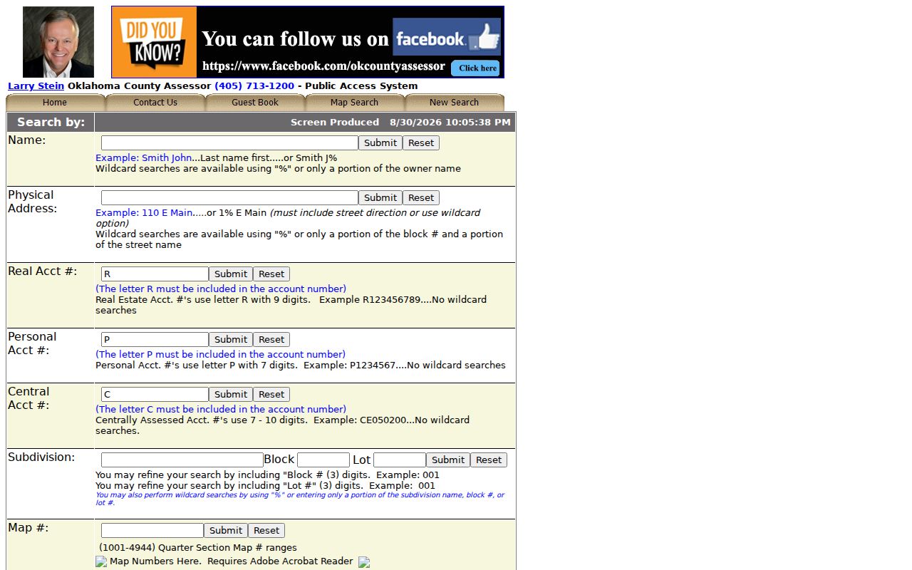
The separate search routes shown there are why a missing street match can be retried through a legal description or account rather than guessed from a nearby property.
Map a Del City Street Parcel
The GIS Hub adds street context to a Del City address search. The county describes searchable owner, physical-address, account, legal-description, and street-intersection functions, along with parcel layers connected to account data. Available context can include new plats, subdivisions, parcel splits, city boundaries, school districts, floodplains, contours, and aerial photography. Use the layer to identify the target parcel, note the addition and lot pattern, and see whether a city limit or road right-of-way affects the address.
Do not turn the map into proof of residence. A GIS neighbor is an adjoining shape on a displayed layer. It may be a corner lot, common area, alley, tract split, condominium, or recently recorded parcel. The Assessor directs researchers to the deed for the definitive legal description. The current hub is preferred if the legacy viewer redirects or fails.
- Parcel
- A county-recognized piece of land, usually tied to an account and legal description. It can include more than one structure or no occupied structure.
- Situs address
- The physical location used for the property. It can differ from the owner’s mailing address and should not be treated as occupancy proof.
- Plat
- A recorded map of an addition, subdivision, lots, blocks, or dedications. It can explain the legal description behind a street address.
- Criss-cross directory
- The street-order portion of a directory, used to move from a printed address toward a dated name entry.
Note: Record the map date and layer name so a later parcel change does not silently rewrite the Del City street result.
Del City Street Records by Address
Several custodians keep records that can be keyed to a Del City street, but they have different limits. The Assessor and Treasurer can place an account in a time frame. The Clerk’s instruments provide the legal chain. The GIS Hub supplies map context. City departments can hold defined municipal files, though a public permit index was not located. Historical collections can place a name at a printed address in one year. Treat each source as a dated lead rather than a master list of people on the street.
| Address-keyed source | Custodian | What to retain | Access channel |
|---|---|---|---|
| County account | Oklahoma County Assessor | Account, physical/mailing address, legal description, subdivision | Free online search; office and GIS support by phone |
| Recorded instrument | Oklahoma County Clerk, Registrar of Deeds | Grantor, grantee, type, recording date, book/page, legal description | Online index, in-office inspection, recorded image or official copy |
| Parcel map | Oklahoma County GIS Hub | Geometry, adjacent parcels, city boundary, map date | Online map; map context only |
| Tax account | Oklahoma County Treasurer | Account, tax year, paid or unpaid status | Online account or name/address search |
| Permit or code file | Del City Community Development or Code Enforcement | Defined category, street, date range, releasable status | Focused request; no public permit-index search located |
| Historic street entry | Metro Library or OHS | Year, printed address, name, page, publisher | Library, Research Center, database, microfilm, or staff request |
The County Treasurer provides current-year and six prior years of tax accounts, plus unpaid accounts for all years and unredeemed tax-sale liens. That can help date an account, but payment status is not proof that someone occupies the property. The Oklahoma Voter Portal requires last name, first name, and date of birth for an individual registration check. It is not an address-browse tool.
Follow Del City Deeds from a Street
Once an Assessor account yields an addition, block, lot, or other legal description, use that wording in the County Clerk index. Capture the grantor and grantee, instrument type, recording date, book and page or instrument number, subdivision, and related plat reference. Then read the recorded image or ask the Clerk for the official copy. A grantor is the party transferring an interest. A grantee is the party receiving it. Those names can be leads for earlier instruments, but the legal description is what keeps the chain on the same land.
The Oklahoma County Clerk is the Registrar of Deeds at 320 Robert S. Kerr Avenue, Room 203, Oklahoma City, 405-713-1540. It is open Monday through Friday from 8 a.m. to 5 p.m. The public index is informational, can lag recording, and may omit sensitive document types. The office directs users to inspect official records in person when necessary. Listed fees include $18 for the first page of a deed, mortgage, or instrument, $2 for each additional page, $1 per recorded-image copy page, and $1 for certification. Confirm the fee before ordering.
Compare the recorded legal description with the Assessor and GIS records. An owner name alone can match a different parcel, while a mailing address may be outside Del City. A newer transaction can also appear first in another county system before the Clerk index updates. The county’s deed-alert service can send a notice when a recorded document contains a subscriber’s name, but common names can create false alerts. It is a prompt to inspect the index and instrument, not a title search.
Del City Street Labels Through Growth
Historic street research needs the place name that existed at the time. Del City’s early development was around SE 29th Street and Sunny Lane. The city incorporated in 1948 after its postwar settlement began. OHS also records the absorption of Carter Park in 1954, Midway Village in 1963, and the final Tinker-area boundary resolution in 1964. A street or address from those periods may appear under a predecessor neighborhood, Boone Township, Oklahoma County, Oklahoma City, or a publisher’s metropolitan coverage label.
Use those dates as search filters, not as a reason to assume an address changed. For a 1953 item, try Carter Park and the nearby addition. For a later entry, search Midway Village and Del City. At the Tinker edge, compare instruments, plats, maps, and city minutes from 1964. No official comprehensive history of Del City street renumbering or renamed streets was located. A change needs dated evidence, such as an old and new form plus a deed, plat, ordinance, or map that explains it.
Note: When the legal description remains stable but the street label differs, preserve both forms and investigate the parcel chain before calling them the same address.
Find Del City Street Variants in Print
Metro’s home-history guidance recommends pairing directories, Polk material, census records, Sanborn maps, newspapers, and Gateway to Oklahoma History. Older print sources may spell out a house number or direction. Search both SE 29th and Southeast Twenty-Ninth, a numeric number and its written form, the street and a nearby intersection, plus the addition name from the plat. A newspaper hit can provide dated social, legal, sale, or civic context, but the underlying deed, court, or vital record remains the confirmation source.
The OHS plat-map index is useful before a keyword search because it supplies addition names, city labels, dates, and land descriptions. Turn those terms into a short vocabulary list, then search them in the County Clerk index, Assessor, directories, and Gateway. The OHS home-history guide is the practical route for this kind of address work. A plat bridges a modern parcel to the historical label a directory or newspaper may have used.
Read the Del City Street Index
Historical street-by-street work belongs in a directory’s street index, also called a criss-cross section. Metro explains that city directories usually have alphabetical resident and business entries, a street index, and a classified section. Search the street index for a number and name, then compare the result with the alphabetical page in the same volume. A second nearby year is important. It can separate a printing error, a move, and a change in the way the address was written.
Metro says its city directories reach back to 1902 through Special Collections and Research, with online access paths through its databases. Exact Del City-specific volume coverage was not located in public text results, and a separately titled Del City criss-cross run was not confirmed. Ask staff to check Polk, city, and telephone directories for the street and block. The historical collections themselves are covered in more detail in the Del City city directory collections.
If a page uses symbols such as r or h, transcribe them exactly and photograph the abbreviation key in that volume. Their meaning can vary by publisher. A street-index name is a dated printed clue, not proof of present occupancy.
Request Del City Address Files
Some address evidence is municipal rather than county-held. Del City Community Development lists building, demolition, floodplain, grading, stormwater, pool, right-of-way, public-works, and temporary-activity record categories. Code Enforcement lists several complaint categories, including tall grass, junk, derelict vehicles, stormwater, utility-meter tampering, and occupied houses without utilities. Neither description establishes that a record exists at a particular street, and no public permit-index search was located. They are a menu for a precise request.
Use the Del City Open Records Request Form to ask for an existing, releasable record series by street address, category, and date range. The form permits physical copies, inspection, certified copies, and email if offered. It asks for semicolon-separated search terms and can require advance payment when an estimate exceeds $75 or there is an outstanding balance. For a code matter, request releasable closed records or status information. Complainant identities and active-case information may be restricted.
Police records use a separate request form and different release rules. Ask for a defined incident, case number, location, and time window rather than a person list. The city says ordinary police requests commonly take five to seven business days, although complexity and exemptions can change the result.
Limits on a Del City Street Search
A Del City street directory cannot show every person connected to an address. The Assessor owner field, a mailing address, a deed grantee, a directory entry, and a GIS parcel each describe a different record relationship. Oklahoma’s voter system protects certain addresses through the Restricted Records Program and Address Confidentiality Program. A missing result can mean protected, not public, not digitized, not indexed, or not found with the terms used. Record each outcome and its retrieval date instead of treating it as a negative fact.
For a city-held record, ask the correct custodian for an existing file rather than a custom household list. Del City’s open-records form supports inspection, physical copies, certified copies, and email if offered. It asks for a date range and semicolon-separated search terms. For permits or code matters, identify the address, defined record category, and time window. Complaint identities and active-case information can be restricted, and police material can be redacted for safety or other legal reasons.
Lawful use. Use Del City address records for personal, lawful research and protect private information. Do not use a street search to stalk, harass, intimidate, or harm anyone.